Yazılar

Greenland’s Glaciers Shrink, Revealing 1,620 km of New Coastline Since 2000

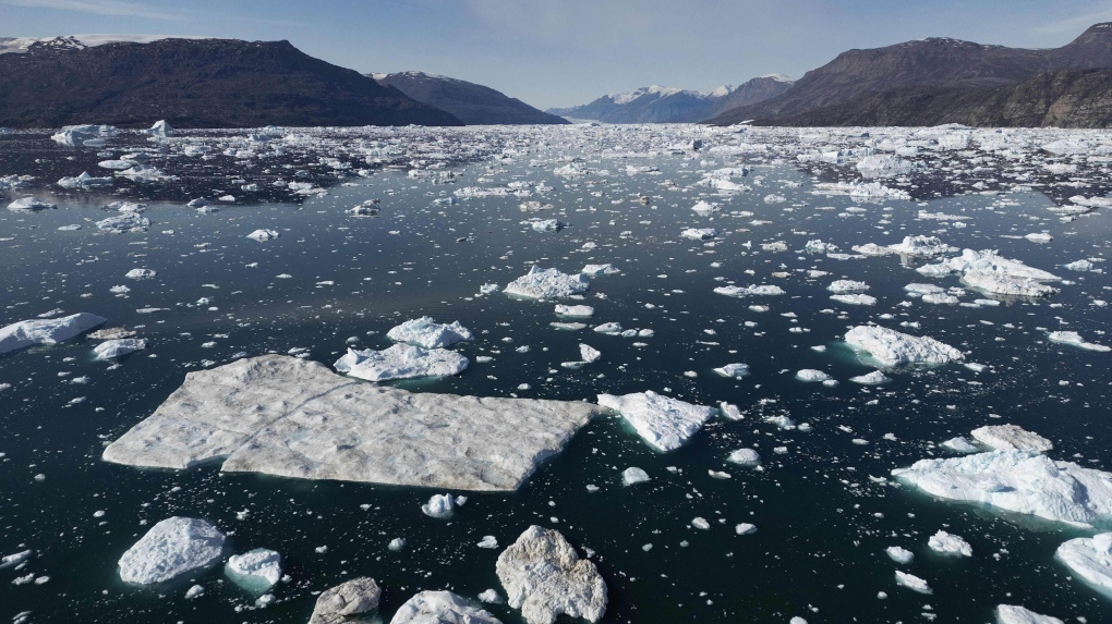
Greenland’s rapidly melting glaciers have revealed an astounding 1,620 kilometers of previously ice-covered coastline over the past two decades. As Arctic marine-terminating glaciers continue to retreat, satellite imagery from 2000 to 2020 has documented this significant shift, showcasing the broader impacts of global warming on the region’s geography. These changes not only highlight the shrinking ice flows but also bring forth newly exposed land that is now open to environmental shifts. The newly uncovered areas are likely to face various ecological challenges, including shifts in local ecosystems and sediment movement, while simultaneously presenting opportunities for further scientific exploration.

A study published in Nature Climate Change examined satellite images to track the changes in glacier coverage across the northern hemisphere. The results showed that over the past 20 years, 2,466 kilometers of Arctic coastline have been revealed by glacial retreat, with Greenland accounting for approximately 66 percent of that total. One of the most striking examples of this phenomenon is the Zachariae Isstrom glacier, where 81 kilometers of coastline have been exposed, marking the most significant glacial retreat in the Arctic—twice the amount of any other glacier in the region.

In addition to the coastline, the melting glaciers have led to the discovery of new islands, some of which were previously hidden beneath the ice. The study found that 35 islands larger than 0.5 square kilometers have emerged as a result of the ice retreat, with 29 of these islands located in Greenland. Some of these newly uncovered islands have never been shown on any maps, raising concerns over potential territorial claims. As nations vie for control over these newly exposed lands, there are concerns about the rush to stake claims due to the region’s natural resources.

The emergence of these islands is not only a matter of political interest but also scientific curiosity. Researchers highlight the significant potential for studying the Arctic’s unique geology and marine ecosystems, with the newly exposed areas providing fresh insights into the region’s environmental history and biodiversity. These shifting landscapes offer an unprecedented opportunity for understanding the Arctic’s rapidly changing environment, but they also underscore the larger consequences of climate change on global ecosystems and geopolitical dynamics.

SWOT Satellite Captures Seismic Tsunami Event in Greenland’s Dickson Fjord

In September 2023, the Surface Water and Ocean Topography (SWOT) satellite, a collaborative mission between NASA and France’s Centre National d’Études Spatiales (CNES), recorded an extraordinary seismic tsunami event in Greenland’s Dickson Fjord. This unprecedented event, caused by a massive rockslide, led to a nine-day sequence of waves reverberating throughout the fjord. The event is notable for being one of the few instances where satellite technology captured such a prolonged natural phenomenon with remarkable precision, providing valuable data that could aid in understanding similar events in the future.

The rockslide, which unleashed over 25 million cubic meters of rock and ice into the fjord, displaced vast amounts of water, creating a series of massive waves. These waves, which oscillated between the fjord’s steep walls every 90 seconds, continued for nearly a week, making this a rare and unique event. According to NASA’s Jet Propulsion Laboratory scientist Josh Willis, SWOT’s advanced technology allowed researchers to observe the wave contours in unprecedented detail. The wave height variation between the northern and southern sides of the fjord, with water levels rising by as much as 1.2 meters, demonstrated the immense force of the rockslide’s impact.

What makes SWOT’s detection particularly groundbreaking is its use of cutting-edge radar technology. Orbiting approximately 900 kilometers above Earth, the satellite employs a Ka-band Radar Interferometer (KaRIn) to measure water surface heights with exceptional accuracy. This technology proved crucial in capturing the dynamic effects of the tsunami in the remote, narrow fjord, where conventional altimeters with larger measurement footprints would have struggled. The satellite’s precision allowed scientists to observe the tsunami’s full duration and track its rhythmic movement, which was not possible with previous methods.

SWOT’s ability to detect and monitor such an event emphasizes the growing importance of advanced satellite technology in global hazard monitoring. According to Nadya Vinogradova Shiffer, a NASA scientist, SWOT’s precise measurements could significantly improve preparedness for natural disasters by providing real-time data that enhances risk assessment and management. This event highlights the satellite’s potential to monitor not just oceanic phenomena but also smaller, more localized natural events, contributing to a broader understanding of Earth’s dynamic systems and aiding in disaster risk reduction.

Massive Greenland Landslide Triggered Nine-Day Tsunami, Shaking the Earth

A monumental landslide in Greenland’s Dickson Fjord caused a colossal tsunami that reverberated through the Earth’s crust for nine days. This unprecedented event, which occurred last September, was initially detected as an unusual seismic signal picked up by global sensors, prompting an international scientific investigation.

Tsunami’s Origin and Impact

The landslide involved a massive collapse of a mountainside, dislodging approximately 25 million cubic meters of rock—equivalent to 25 Empire State Buildings. This debris, along with glacial ice, generated a 200-meter-high mega-tsunami. Unlike typical tsunamis, which dissipate quickly in the open ocean, this wave remained trapped within the fjord’s complex, narrow system. The wave’s energy was contained, causing it to oscillate back and forth within the fjord for an extraordinary nine days.

Dr. Stephen Hicks from UCL, who was part of the investigative team, noted that the seismic signals from this event were markedly different from those of an earthquake. “When we first detected the signal, it was unlike anything we had seen before,” Hicks explained. The persistent seismic vibrations, appearing every 90 seconds, led scientists to initially classify them as an “unidentified seismic object.”

Investigation and Findings

The investigation, which involved collaboration between an international team of scientists and the Danish Navy, used a combination of seismic data, satellite imagery, and photographic evidence. The team pinpointed the source of the seismic signals to Dickson Fjord in East Greenland, where a satellite image revealed a cloud of dust in a gully. Subsequent photographs showed that a mountain had collapsed, sending part of a glacier into the fjord.

The researchers’ model demonstrated that the tsunami’s energy did not dissipate but instead created a prolonged series of wave movements within the fjord, an unprecedented phenomenon in the field of tsunami research.

Climate Change and Rising Tsunami Risks

The landslide was attributed to rising temperatures in Greenland, which have caused glaciers to thin and lose their supporting role for surrounding mountains. Dr. Hicks highlighted that this event underscores the impact of climate change on geological stability. “The glacier that supported the mountain had become so thin that it could no longer hold the mountain up,” he said. “This shows how climate change is affecting these areas.”

Although this event occurred in a remote fjord, it serves as a warning about the potential risks associated with climate change. The lead researcher, Dr. Kristian Svennevig from the National Geological Surveys for Denmark and Greenland (GEUS), emphasized that such giant landslides and tsunamis are becoming increasingly common in the Arctic. “While this specific event does not confirm a broader trend, its scale highlights the need for further research into these phenomena,” Svennevig stated.

Conclusion

The Dickson Fjord landslide and its resulting mega-tsunami represent a significant and novel climate change impact, with effects observable in seismic data worldwide. This event underscores the urgent need for continued monitoring and research into the environmental changes driving such dramatic geological occurrences.