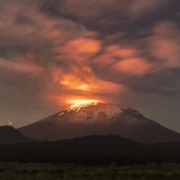
Scientists Capture First 3D Images of the Interior of Mexico’s Popocatépetl Volcano
Scientists from National Autonomous University of Mexico have produced the first three-dimensional images of the interior of Popocatépetl, one of the world’s most active volcanoes and a major threat to nearby population centres.
After five years of fieldwork and data collection, researchers used seismic sensors and artificial intelligence to map the volcano’s internal structure down to about 18 kilometres below the crater. The images reveal multiple magma reservoirs at different depths rather than a single magma chamber, offering new insight into how eruptions may develop.
The project leader, volcanologist Marco Calò, said the findings help explain where magma accumulates and why seismic activity is stronger in certain areas, particularly on the southeast side of the volcano. Around 25 million people live within 100 kilometres of Popocatépetl, making accurate monitoring critical for risk management.

The team expanded the existing seismic network around the volcano and analysed ground vibrations using AI-based algorithms adapted for Popocatépetl’s unique behaviour. This approach allowed researchers to distinguish different types of tremors and infer temperature, depth and material composition underground.
Scientists say the 3D model will improve eruption forecasting and help authorities respond more effectively during periods of heightened activity. The research is set to be published soon and is expected to serve as a baseline for tracking future changes inside the volcano.